The amount of hate this project is getting in the comments is just incredible...
Very little airport surface data is made available in an open and machine-readable format (aerial navigation data is available openly in the US at least). Because of this only the big players (e.g., Boeing) have this data. OpenStreetMap users who contribute this data are democratizing access for anyone who wants to work with airport data in the same way global map data is democratized.
At the same time, data is only useful if you can make sense of it, and the first task towards being able to work with this data is visualizing it. A specialized mapping tool helps a lot here. Props to the author for making it!
One example use case: citizen scientists could develop and test new planning algorithms for airplane taxiing that are resistant to blockages and availability problems. This is science you could do right now only because data like this is available.
Thanks for this. Using this data at the carrier where I work, we’ve been able to automate compliance with rapidly evolving regulations on C-band interference with aircraft radar altimeters, long before we even deployed a single C-band site. This data is far more useful than any of the government sources that we have.
I actually expected to see a map of insides of the airport: check-in stalls, security control, lounges and shops. Some places even had those, but it is painted over with an orange "this is an airport building" matte plate.
I checked original OSM and it seems to me that most airports there are more or less mapped. I checked Belgrade, Sofia, Vienna and Nurnberg. Every one has icons for security check, car rentals, gift shops and so on.
Very nicely done and very responsive. The one thing I'd love to see added is information on which airlines use which gates. I know airlines often share gates, but even knowing which gates are most likely for a given airline would be useful. In Atlanta, I like being able to fly out of a T-Gate because it has its own security checkpoint that's typically, but not always, faster than the main security checkpoint. I think those gates are mostly used by American and United but would be nice to see it listed on each gate.
For what it's worth, all gates in Atlanta are connected airside, so you can use that checkpoint no matter which gate you're ultimately flying out of.
If you haven't done so, it's actually quite nice to skip the Plane Train and walk between the concourses; there's a very cool collection of Zimbabwean sculpture down there between the T and A gates.
If I have a longer layover in the Atlanta airport, my trick is to go all the way to the end of the line, to the international terminal. It's much quieter and less busy than the other terminals, and you can read/surf in peace.
It's nice but not very responsive. We switched from leaflet (this seems to use that as well) to maplibre last year for this reason. Zooming and panning are a bit slowish.
Looks very nice. But I was a bit confused by the UX. If you close your current airport it is still selected. I think it would be nicer if you could select an Airport with the map afer closing, rather than only using the searchbar.
What is the end goal of this project? Mapping runways and taxiways isn't ... useful? At least in the United States if it's a field big enough for a K-designation, then there is an Airport Diagram published by the FAA. And therefor public domain.
Something like OpenStreetMap makes sense because there is no public domain published map of everything. I'm sure there is something obvious here I'm missing. Maybe it's just anything that isn't US might be the problem.
I personally would love a map telling me which parts of which airports are most connected airside, and average moving times between different regions of the airport.
The data is from OpenStreetMap. That has a ton of data inside airports that we frequently make use of, including things like water fountains and toilets. One thing that is a bit difficult is determining whether something is before or after security, though. Depends on the airport and how well you know it.
You can use an app like Organic Maps (formerly Maps.me) or Osmand to access it.
This is a neat looking site, but for some reason on Firefox it prompts for location every few seconds. I allow it, but don't check the 'Remember this decision' box. It even is showing my current location and still popping up the box. This is the first time I've seen a site do this... Maybe it's turning on and off detailed location repeatedly?
That's a browser's default behaviour when the location is requested without user interaction. In this case they request the location immediately when opening the page, they're supposed to add a "Use my location" button and in that case the browser would remember the decision for the current session.
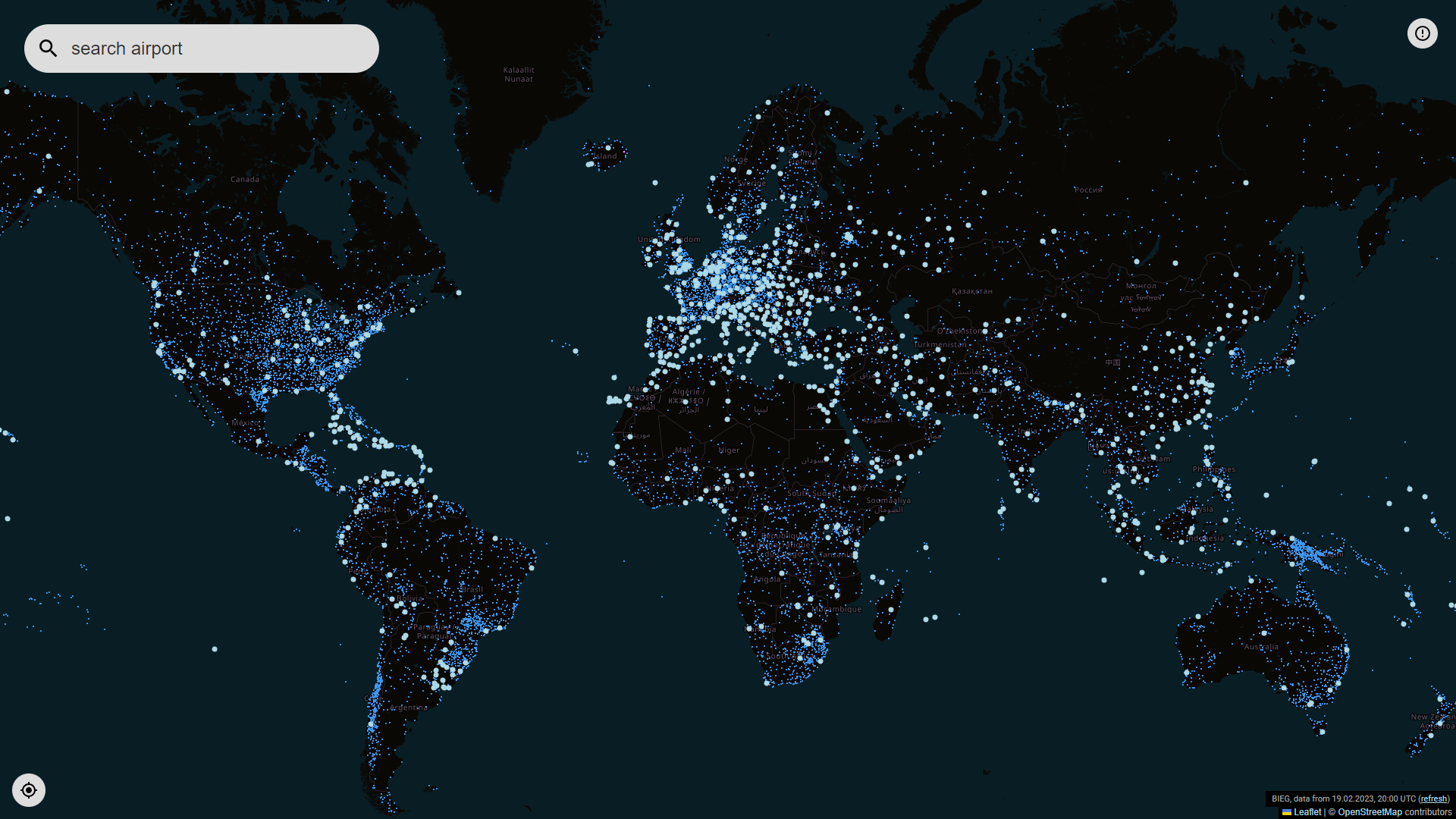
A bit disappointing that one has to search for an airport to have it displayed. One of my favourite parts of OpenRailwayMap is to explore tracks I'm unfamiliar with (particularly abandoned tracks), but this map seems to require one to know where one is going, rather than exploring.
That is true, zooming in on an airport won't let you see its features, you'll have to read its name and put it on the searchbox for that part of the map to be displayed. You'd expect that zooming in on an airport would allow you to see it, or at the minimum to be able to click on an airport to load it up.
I just spent 20 minutes flying to various airports I've been to in person. Curious to see space/gate/terminal efficiency and closeness from one central point at eg DUS and FRA with the evolution that is LHR.
LUX and LCY are also interesting: comparable max passenger numbers of 4M-5M, LUX has 2x> as many weekend slots as LCY, presumably similar clientel (though LUX does more hub flights I reckon), and very different space and layout constraints.
Out of interest, did you move into a property before or after the airport was built?
The reason I ask is that one of my local GA airports has constant pressure to reduce the movements from local residents, but the airport has been in frequent use since WWI so I can't understand why people move near an airport and then complain that there is an airport there.
LUX is a much bigger air cargo hub than a passenger airport; that's the difference. There hasn't been long-haul/wide-body passenger service there in many years, but that 4000m runway sees real use. Usually 50% more freight aircraft movements (and many multiples the mass) than passenger aircraft at LUX.
LCY is a one-trick-pony: a private airport for European finance bros.
The official website shown for IAH is a limo company. Looks like not great web scraping. I also find this unattractive and not useful, and I love airports.
Apparently, they use Wikidata, where this was listed as the official website. I fixed it on Wikidata and it appeared fixed on the website immediately as well, so they apparently fetch the data online, no prior download nor caching?
Love open flight data! So much of it to go around, it’s one of the few topics where there is practically too much free data to use. Reminds me of https://tsa.report and https://openflights.org/ etc
Looks more like a cad drawing than a map. I'm sorry but as a rather prolific former cartographer (I've made thousands of maps for hundreds of clients) what is the goal of this map? Showing terminal locations? Where to park? Size relative to surroundings? Location of manholes? Noise compatibility?
I’m sorry but as a pilot who routinely uses airport diagrams what specific weakness are you seeing? As you are probably aware, not all maps are intended to have some beautiful aesthetic. This map is quite akin in style to the layout of airport maps (diagrams) published for actual pilot use.
As a frequent flyer on small aircraft (nearly all of one side of my family has worked in aviation: cessna, boeing, piper, beech, embraer) - this looks nothing like the charts I'm used to viewing.
That doesn’t answer the question: what is wrong with the map? As a non pilot I can’t say that I find an airport diagram from the FAA more insightful: https://aeronav.faa.gov/d-tpp/2302/00375AD.PDF
I am a pilot, and I compared the FAA diagram of SFO that you pointed out with the openairportmap.org one. Looking at the map itself:
* Taxiway labels aren't very readable, and I need to zoom in quite a bit for them to even be consistently displayed.
* For that matter, the yellow lines seem to cover a lot of things that aren't taxiways, and seem to extend into non-movement areas (areas outside the purview of ground control/tower), and for that reason, they make the actual taxyways harder to see.
* The runways are labled in a way that requires consulting the compass rose to interpret - "10L/28R". "10L/28R" is the name for that strip of tarmac, but when you're landing with a heading of 284º, it's called "28R" and when you're landing the other way, it's called "10L". Compare that with the FAA diagram, which labels them clearly at the landing side of the runway, the same way the numbers are painted on the ground.
* The openairportmap diagram lacks runway length and width.
* OpenAirportMap lacks the location of the displaced thresholds on the 28 and 1 runways.
* OpenAirportMap lacks the location of the runaway airplane catchers (EMAS) at the ends of the 1/19 runways.
* OpenAirportMap lacks any field elevation information
* OpenAirportMap doesn't have an indication of north, or of the magnetic variance.
* SFO doesn't have a VOR on-field, but if it did, it's location would be printed on FAA map, but not openairport
* The FAA map has the ATIS (weather), Tower, Ground Control, and Approach Control frequencies listed on it.
Overall, I would say the openairport map is not useful to a pilot. Which I think goes to the GP's point: "what is the goal of this map?" It's not to help a pilot.
First, "this is not for pilots", it probably can be.
Second, the layout/design is not helpful, seems to be mostly nit picking (which is good).
Third, the data is wrong.
The data can be corrected on http://osm.org by anyone, so that means your first objection is true. The design and layout can of course be corrected over time, depending on how many people care about mapping/visualizing them. The question is can you land an airplane with this map, this will be tested in flight sims that will use the same data.
So I do not know the goal of this map, but I have entered data about airports in to Openstreetmap and I most certainly did not do it for pilots. This was ten years ago I see that the amount of data has grown incredibly, So there must be people that care about it. That makes me believe that all your objections will be solved. Except the first one I listed since we can't have an fully loaded passenger plane land based upon my data.
This obviously isn't for pilots (as a pilot you don't want to use information that anyone can edit at anytime). It's just a different way of highlighting lots of airport-related information that is available in OpenStreetMap, which is a cool thing to do.
Clearly nobody is going to cancel their Foreflight subscription for this. But the point is that the map is short on aesthetic details because its goal is to allow visualization of a complex dataset, namely airport surface features.
If you’re a Cartographer and have made thousands of maps surely you know that some maps are for different audiences and use cases. This might just seem odd to you because you haven’t used this information in a manner laid out here, but trust me that it’s valuable!
It shows airport data from OpenStreetMap. It's posted on a site targeted at software developers. Is it that much of a stretch to conclude it's for use by people interested in machine-readable data on airports?
>>Unless you somehow prefer reading raw xml instead of maps.
Pretty sure I clearly stated this looks nothing like the charts im used to. Further real world comments above explain why this map is to put politely, lacking.
Major major difference between maps and data. Perhaps sitting in on Geog 120 or whatever it is wherever you are, would be wise. Hop in a seat of a Cessna 150 would too.
I'm confused why it shows detail like holding position markings, but not taxiways or hot spots. And it conflates locations using different hold short markings (ILS and runway).
In Frankfurt at least I see the ILS critical areas tagged with "holding_position:type: ILS". For instance south of arrival end 25C. Looking at aerial imagery these do correctly align with the ILS and hold-short markings.
Edit: it does appear that hold lines are mis-tagged in some spots, e.g. north of arrival end 25C.
It's just showing OpenStreetMap data. Anyone can edit and add data. The data that's in there is just what enthusiasts have added in the past 20 years. If no one added it, it's not there. You can add data if you like.
It is a visualization of community-sourced (OpenStreetMap) data on airports. This data is clearly supported as Frankfurt does have many surfaces labeled. Working towards making this data available is useful even if every single item isn't there.
I wouldn't necessarily say it is. It's an automated visualization of machine-readable data on airports. If you were processing this data, you'd want a visualization like this.
This has all the information a pilot would need to take off and land from an airport. Airport maps are usually available for free in US but at least I have yet to find some for some Canadian airports. The Canadian organizations sell those. There are paid apps you can get. This looks like a good free alternative.
Addendum: someone mentioned Airnav. Just to see the lack of open and up to date data available freely, look at SFO [1] and look at YYZ [2]. SFO has an airport diagram showing taxy ways and runways and some other meta information. nothing for YYZ.
It seems like whether or not it has what a pilot needs depends on how thorough the OpenStreetMap contributors have been for a particular airport. (As an extreme example, CYHZ in Halifax seems to be missing completely, but the tiny CYTN in Trenton, NS is diagrammed).
For some reason it couldn't find LAX's full designation, KLAX. Also, just realized SNA, an tiny local airport, has a whopping 5000+ft runway, longer than some major ones like SFO or BOS.
Very nice! But when I try to look at LAX it says: Couldn't find airport with ICAO code "KLAX". All other airports seem to work though, so this is a strange bug.
"remark": "runtime error: Query timed out in \"query\" at line 6 after 29 seconds."
I say bogus error message because for sure that URL did not take 29 seconds to return (221ms according to Firefox). I'd guess the query is malformed and their api interprets the error as a "timeout" instead of "error"
Open the developer tools, choose the network tab, click on "XHR" to filter down the noise, type LAX into the search box, and then watch the things that change. After it presented the error message, I looked for things named KLAX in the list, clicked on that row, clicked on the Response pane and saw that silliness
Neat, but with the usual USA-centricism: Despite the map starting at Frankfurt (the one in the west of Germany), and me being in Berlin (the one in the east of Germany) the first result for "Berlin" was the one in New Hampshire, USA.
That could have sooo many reasons. "Berlin Municipal Airport" does come before "Flughafen Berlin Brandenburg" in the alphabet.
But.. looking for "London", 2 of the first 3 airports are in North America and arguably a lot of people would not count any of the first 5 (Lydd, Oxford & Southend) as London. Heathrow doesn't show up at all without specifying further.
There's a few other areas where the text is suspect, e.g the international airport for Bali, in Denpasar won't show up in searches for Bali (colloquial name of the airport) or Denpasar (city referenced by the IATA code) both of which work in regular flight search, but requires entering the airport codes or its formal name Ngurah Rai. Extra confusion as there is a tiny airport called Bali Airport in Cameroon which shows up instead...
In theory, they could build a system which returns relevant airports ranked by size in terms of latest/peak passenger traffic figures
    addr:city=Denpasar
    aeroway=aerodrome
    iata=DPS
    icao=WADD
    name=Bandar Udara Internasional Ngurah Rai
    name:de=Internationaler Flughafen Ngurah Rai
    name:en=Ngurah Rai International Airport
    name:fr=Aéroport International Ngurah Rai
    name:ko=응우라라이공항
    operator=PT. Angkasa Pura I
    short_name=Bandara Internasional Ngurah Rai
    type=civil
    wikidata=Q1061846
    wikipedia=id:Bandar Udara Internasional Ngurah Rai
How do these peripheral airports get to name themselves in such a misleading way? 'London Oxford airport' isn't even in Oxford; locals still call it Kidlington airport.
"only" supports airport codes is definitely not true, though text search outside of airport codes, as others have noted, leads to some odd sort ordering.
I don't think being built by a German speaker has anything to do with it. Typing "Vienna" (the English name for the city) returns the expected airport first, perhaps because the IATA code is VIE. Typing "Wien" (the actual name of the city in German, used by the locals) puts it further down the list among funny little airfields in other places.
The UX lesson for us all: sorting of search results is hard. It helps to know who your users are, and what they are looking for. Fundamentally, my bigger question with this site - which looks awesome, and is fun to geek out over - is who is it for? Professional pilots obviously have their own resources already to tell them how to navigate around airports, where to park and where to taxi; the detailed information that would actually be useful for a first-time passenger at Frankfurt airport is completely lacking, eg. how long will it take me to transfer from an inbound London flight to my connection to a small town in Austria, how can I find shortcuts to shave a few minutes off that, will I have to go through extra security checks (the answer varies with the direction of travel and, apparently, the time of day), is it more convenient to stop off in the business lounge of the terminal where I arrive, before transferring, or the one that might be close to my departure gate, can I still enter Schengen through the electronic gates with a UK passport or must I join a long queue with the Americans and Japanese, where can I refill my water bottle and charge my phone for free, etc etc etc
It's using simple title search. The municipal berlin airport in the us name is shorter so it comes out on top. It has no notion of one Berlin being more important than another.
The UX lesson here is that geocoding names to coordinates is hard. It's always a bit subjective. Another lesson is that search ranking is hard. Even though this is fine, it could be improved a little:
- take into account distance
- take into account size of the airport (number of graphical elements, runway, surface area, etc.)
- take into account size of nearby cities (there is some open data for that)
So many bad practices.. it changes the URL at every action to store your new coordinates/zoom levels, but adds to the browser history instead of replacing it.
Also the whole asking for location unprompted, and not respecting a refusal... dumb.
Very little airport surface data is made available in an open and machine-readable format (aerial navigation data is available openly in the US at least). Because of this only the big players (e.g., Boeing) have this data. OpenStreetMap users who contribute this data are democratizing access for anyone who wants to work with airport data in the same way global map data is democratized.
At the same time, data is only useful if you can make sense of it, and the first task towards being able to work with this data is visualizing it. A specialized mapping tool helps a lot here. Props to the author for making it!
One example use case: citizen scientists could develop and test new planning algorithms for airplane taxiing that are resistant to blockages and availability problems. This is science you could do right now only because data like this is available.